2.10. Pilot Project: Localisation and removal from a thermokarst crater of two radioisotope thermoelectric generators (RITEGs) of GONG type at the Kondratiev navigation beacon site in Ust'-Yanski Ulus of Republic of Sakha (Yakutia)
The Project Goal was to ensure radiation safety and to prevent the risk of radioactive contamination of the water areas along the Arctic coast of Ust’-Yanski Ulus by testing the methodology of identifying the lost – due to the shoreline disturbance caused by intensive coastal thermocarst processes - two RITEGs by applying geomagnetic, electric exploration and radiometric surveys, digging up both RITEGs from a thermokarst crater to the surface and preparing them for transportation and disposal.
The Project was implemented by the individual enterprise “Sell’yakhov” together with Tiksi Hydrographic Facilities (a branch of the Federal State Unitary Hydrographic Enterprise) and Federal State Unitary Research and Production Enterprise “Geology Exploration”.
The Project Duration: 30 April – 30 November 2010
The Project Activities
At the initial stage of the organizational activities for Stage I of the Project, all the required authorizations were obtained to ensure the works safety control including formal permits for these works.
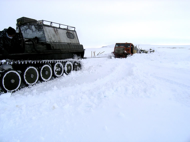
Figure 28. Cat Train on Its Way to Kondratiev Facility
A portable electric piling hoist was made to ensure soil excavation. The required tools and equipment including radio and navigation equipment were also made. From Tiksi Port to the Kondratiev site, a cat train tracked over the ice-covered the Laptev Sea to deliver workers, food products, fuel and lubricants, equipments, and materials needed to prepare the site prior to the arrival of the main team of specialists and workers. The cat train track was selected by analyzing satellite photos and experience of taking such tracks.
In accordance with TOR, Stage II of the Project included the following activities:
- A research team of specialists from FGU NPP Geological Exploration (Saint-Petersburg), workers of IP Selliahov and a representative of Tiksi Hydrographic Facilities were delivered by air to the Kondratiev site;
- Additional preparatory works were carried out. The team established a tent camp, installed a diesel generator, and constructed power supply to the tent camp and to the RITEG search area. The workers also constructed two log frames on the adjacent site, and prepared heat insulation from turf-like sea material;
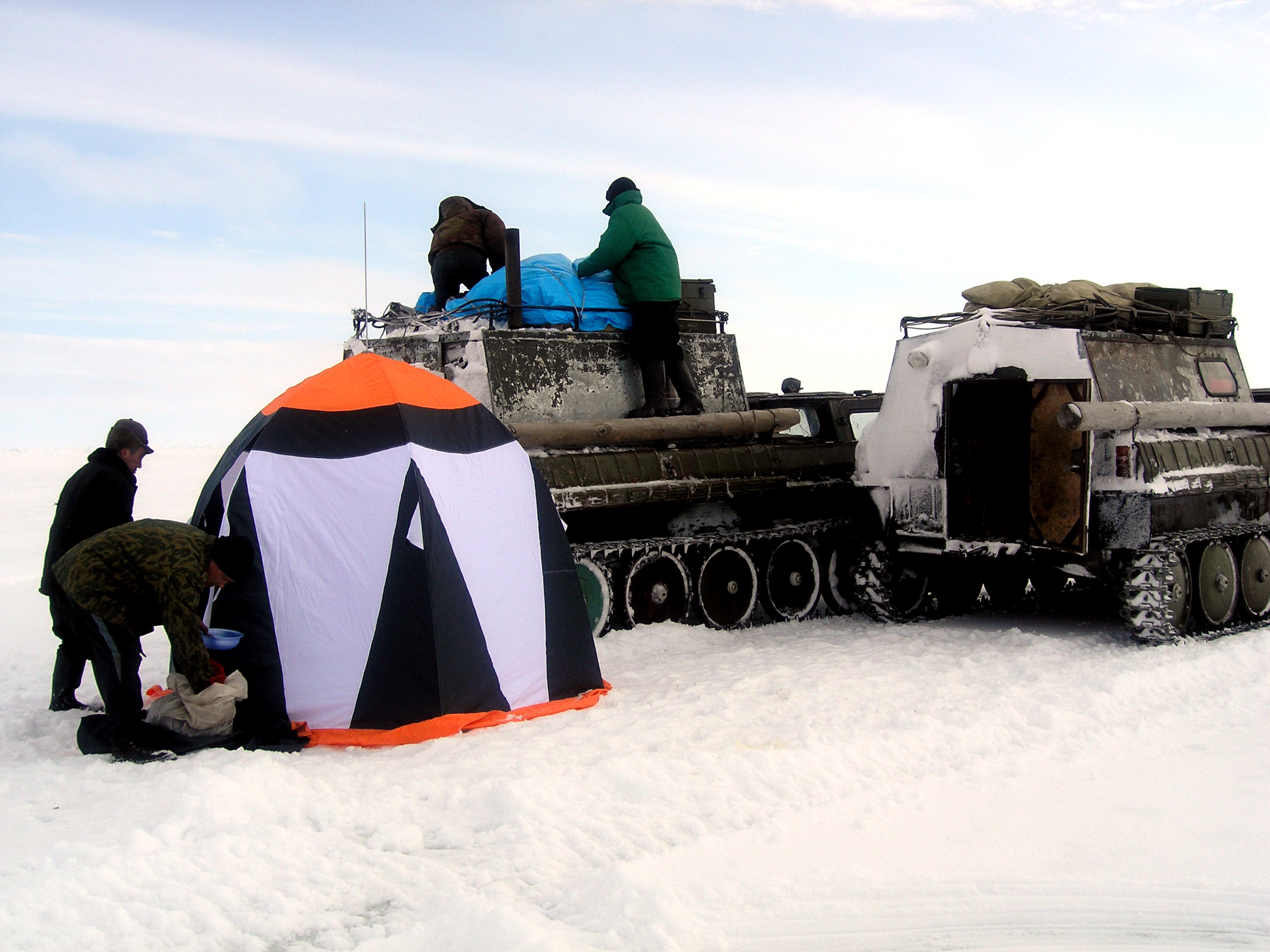
Figure 29. Tent Camp of Research Team
-
The surface area of the assumed RITEG locations was measured for radiation;
-
A site was prepared and cleaned to apply geophysical methods;
-
Geophysical methods were used to study the location. The study identified numerous metal items that generated anomalies and violated the purity of the survey. As such anomalies were identified the source items were excavated and hollowed out. The repetitive application of this cycle (i.e. identification of anomalies – removal of items – search) allowed the team to succeed in obtaining the true picture of a deep anomaly.
In order to identify the cause of the deep anomaly, a trial pit was made in the right slope of the ravine. To prevent the ingress of water and dirt into the pit, a motor pump was installed at the pit mouth. In the vegetable layer on the right and left side of the ravine, drainage ditches were excavated to reduce the ingress of water into the ravine.
A part of the RITEG guard cover was found at a depth of two meters, while at a depth of 2.5-3 m, the RITEG guard cover was found and excavated.
At a depth of 4.5 m, a opening was made in the capsular space (the RITEG burial place). Radiation measurements found no radiation contamination of water and soil in the capsular space.
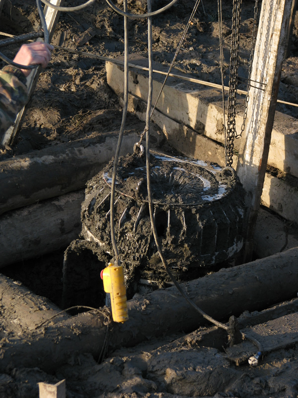
Figure 30. Removing RITEG from Thaw Sink
The RITEG was found upside down at a depth of 6-6.5 m from the bottom of the log frame on the right slope of the ravine. The capsular was shaped as an egg-like space with a diameter of 1.5 m and height of 1.9 m. Melt soil filled 90 percent of the space while 10 percent of the space was filled with water and gas. After the preliminary inspection, prevention and preparatory works, RITEG No.12 was lifted to the surface.
The second RITEG (No.13) was lifted from a depth of 8.5 m from the soil surface.
Both RITEGs were inspected, delivered to Tiksi Hydrographic Facilities (the owner) under the Delivery and Acceptance Certificate, prepared for transportation, moved to a horizontal area, and placed on wooden floor beams (No.12) and on a metal and plastic foam board (No.13). The area was surrounded with a wire fencing bearing radiation warning signs. Safety was mainly guaranteed by the absence of roads, remoteness of settlements (the nearest one is located at a distance of 200 km from the site), and lack of any economic or field activities near Kondratiev site in autumn and winter.
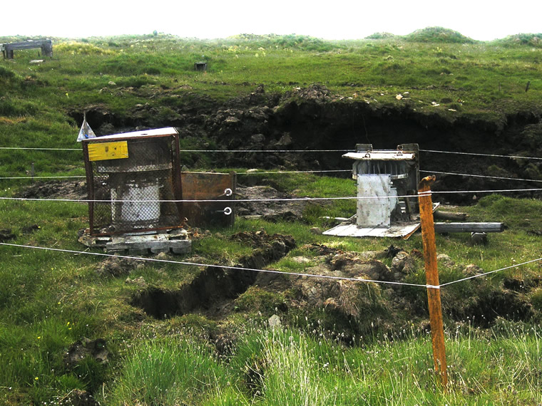
Figure 31. RITEGs Prepared for Transportation
RITEGs will be transferred to Tiksi in the spring of 2011.
The Project Outcomes
The RITEGs location, the depth of their permafrost submersion, the newly formed profile of the area makes it possible to analyze and describe their movement in permafrost. In 2002, employees of the Hydrographic Facilities, that provided for navigation support for the maritime traffic in the Laptev Sea, found that the Kondratiev navigation sign had been completely destroyed and two RITEGs had been lost in Ust’-Yansky Rayon, the Republic of Sakha (Yakutia). The RITEGs kept on sinking during the entire period starting from the collapse of the terrace cusp irrespective of the season of the year. RITEGs were estimated to have moved at a rate of 1.6 – 1.7 m/year having gone down to a depth of 15 and 18 meters. What prevented the RITEGs from sinking even deeper was that they were equipped with trays-runners that acted as parachute brakes (both RITEGs were found upside down). In 7 years, the terrace cusp moved towards the mainland at a distance of 120-130 m, and the distance from the assumed location of the RITEGs to the terrace cusp grew to 180-190 m. From the terrace surface, RITEGs went down to a depth of 9.5 and 11.5 m. Since the pit was excavated in one of the ravines formed on the terrace surface, the depth of excavation was only 3 m.
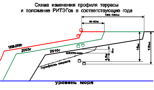
Figure 32. Diagram of Changed Terrace Profile and Location of RITEGs in the Corresponding Years
All the Project equipment items were used. Moreover, there were stand-by devices and equipment as the works were to be carried out in the permafrost conditions in a remote and hard-to-access location. The most needed piece of equipment turned out to be the self-made electric pile hoist that was used in removing foreign items, soil excavation, and lifting RETEGs from the pit.
To carry out works associated with the search for buried RITEGs, it is recommended to apply a set of geophysical methods (magnetic surveys, transient electromagnetic method surveys and radiation measurements). In the arctic regions, geophysical methods in the search for items such as RITEGs, buried in the permafrost soil, must be used in the absence of snow cover. Where the search site has a lot of metal items, such works should be carried out in summer with the maximum thawing of the soil. This will make it much easier to clean the search location from interfering items. This set of geophysical methods will also be good at searching metal items if they have been buried as a result of landslides or other processes.
It is recommended to drive the pit in the permafrost soil only at temperatures below zero. This will exclude cave-ins or water ingress into the pit and will make it possible to do directional or horizontal digging. Also, temperatures below zero allow the use of heavy track-type machinery or other machines for auxiliary and transportation purposes.
| « Previous | Next » |